Research
Published 14 January 2021New insight on Alpine Fault risk
'Scratch marks' point to epicentres of earthquakes. A discovery made in the wake of 2016's Kaikoura Earthquake could help scientists better understand how the big-risk Alpine Fault may unravel
Original article by Jamie Morton published on 11 January 2021 in Whanganui Chronicle, p. 9
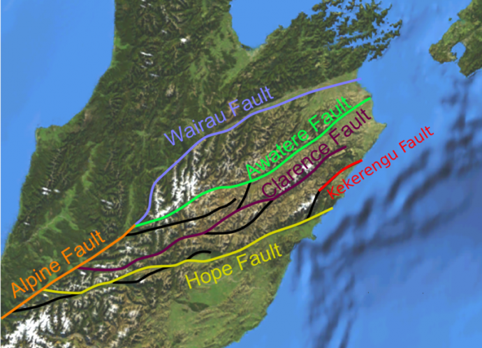
The Alpine Fault, which runs about 600km up the western side of the South Island between Milford Sound and Marlborough, poses one of the biggest natural threats to New Zealand.
It has a clear geologic record of rupturing around every three centuries - and 2017 marked the 300th anniversary of what is thought to have been a magnitude 8 quake that moved one side of the fault by about 8m in a matter of seconds.
Recent studies have suggested a big quake could block South Island highways in more than 120 places, leave 10,000 people cut off, and cost the economy about $10 billion.
Now, a project led by GNS Science's Dr Russ Van Dissen will dig into the hidden system and another large South Island fault the Wairau Fault - to work out which way they'll rupture in the future.
Van Dissen said the direction of rupture propagation, called unzipping, had a major influence on where seismic energy was focused.
Because the 7.8 Kaikoura earthquake ruptured from south to north, it sent a pulse of energy northwards that was sharply felt across the lower North Island - especially in Wellington.
For scientists trying to calculate potential levels of ground shaking in a given area, they typically looked at where, when, how strongly, and in which direction past ruptures had unfolded.
But the last of those four factors remained tricky to quantify.
"A lot of people have carried out modelling and found that, if we knew which way the Alpine Fault would actually rupture, this would be the sort of energy and ground motions it might send to the north, or to the south, and so on," he said.
"But we actually don't know what to look for, or even how to measure which way ruptures have propagated in the past." That was where what were called slip striations or "scratch marks" could prove vital.
"In essence, scratch marks on fault surfaces provide a signpost that points towards the epicentre of the quake," he explained.
"We know that a fault has two sides to it. After one slides past the other, you can notice irregularities - like bear claw marks - that show which way the fault has moved." The importance of these previously-unrecognised markers emerged after the catastrophic 1995 Kobe earthquake in Japan.
"Colleagues came up with a model of how the dynamics of rupture interacted with the stresses and caused these scratch marks to curve near the ground surface." What wasn't noted at the time was how the marks curved differently on each side relative to the epicentre's location. That struck Van Dissen while working on Marlborough's Kekerengu Fault, after the Kaikoura quake.

Russ Van Dissen in the Kēkerengū Fault line rupture. Photo credit: RNZ/Tracy Neal
It was the fault's rupture in November 2016 that created a dramatic rift across kilometres of farmland north of Kaikoura, which became known as the Wall of Waiau.
Rock in this rupture-made wall bore those all-important scatch lines.
"We noticed they were consistently curved one way, so they kind of looked like a big rainbow." Using modelling, they discovered the link between the curves and the epicentre's direction.
"I can't say it was an Einstein moment - we just thought, oh, that's pretty significant." The team planned to revisit the site, and then look for similar markings on sections of the Alpine Fault, along with the Wairau fault, stretching 1000km between Lake Rotoiti and Cloudy Bay.
It was similarly late in its rupture cycle - and also thought to be capable of triggering large quakes.
"The direction of rupture of future quakes on these faults will have a significant influence on the strength of shaking experienced across the South Island and the lower North Island," Van Dissen said.
"If we can show that both faults have ruptured a number of times in a certain direction, then that information could be used to better plan for future earthquakes, and in designing more resilient buildings and infrastructure.
"Large faults are like a heavyweight boxer - you know they are going to pack a wallop. So if you want to prepare yourself, it's helpful to know which direction the energy is going to be coming from." He added that the findings of the collaborative project - supported by a $960,000 Marsden Fund grant - may influence the seismic hazard evaluation, by opening up an archive of past fault rupture directions.
"If what we do pans out, there'd be huge interest in it at places like the San Andreas Fault in California, the North Anatolian Fault in Turkey - basically anywhere there's long strike-slip faults like the Alpine Fault."
Additional information: New study plumbs the depths of the Wairau and Alpine faults
RESEARCHER
Mr Russ Van Dissen
ORGANISATION
GNS Science
FUNDING SUPPORT
Marsden Fund
CONTRACT OR PROJECT ID
GNS2002: 'Geological fingerprinting of earthquake rupture directions: can it be done?'