Research
Published 23 February 2023The Rolling Stones – Uncovering stone rolling dynamics and impact accelerations during floods
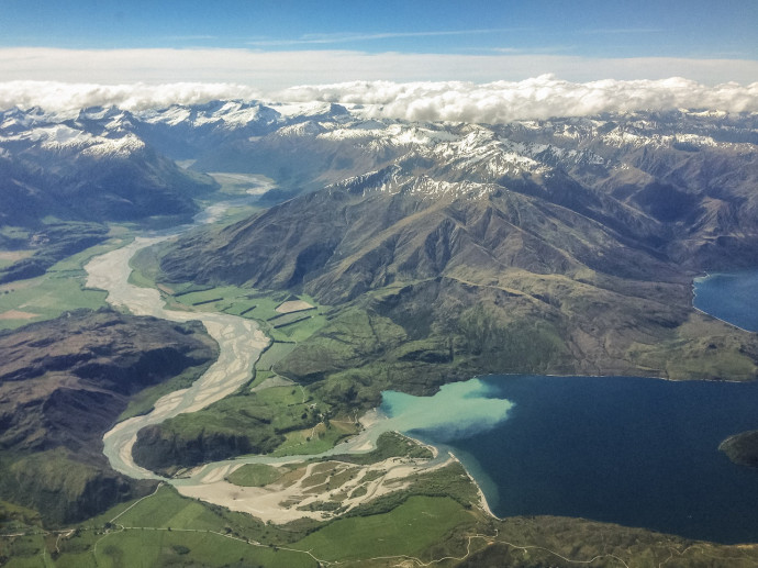
Tectonic activity, weathering, erosion, and sediment transport are key processes that shape the landscapes of the Earth
As the above image demonstrates, sediment transport plays a particularly important role for us, because it is responsible for the formation of alluvial plains and basins - the kinds of terrain that are well-suited to human habitation and agriculture.
This occurs because rivers form a sort of high-energy conveyor belt, which transports sediment from mountains down to lakes and the coast. Most sediment transport occurs during floods. But little is known about the motion dynamics of coarse sediment particles (stones) as they move downstream.
In this Marsden Fund Fast-Start project, Dr Hamish Biggs and his team of researchers at NIWA have addressed this knowledge gap by developing specialised equipment (rugged inertial sensor units) called ‘Kinematic Loggers’ to measure stone dynamics during floods (Figure 1).
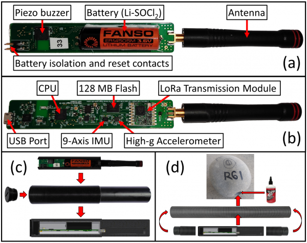
Figure 1: Kinematic Logger showing: (a) top view (b) bottom view. Kinematic Loggers are inserted into rugged waterproof housings (c) then placed inside stones that are core drilled with a diamond hole saw (d).
Figure 1: Kinematic Logger showing: (a) top view (b) bottom view. Kinematic Loggers are inserted into rugged waterproof housings (c) then placed inside stones that are core drilled with a diamond hole saw (d).
These novel sensors were designed to uncover the rolling mechanisms of coarse sediment transport, that have previously been assumed, but never directly measured. They are enclosed in rugged waterproof housings, then glued inside of stones that have been core drilled for field deployments. The sensors feature advanced power management systems, where they sleep until awoken by motion or to send recovery radio messages. The design of the sensors enables them to be placed into the extremely violent and harsh environment at the bottom of a flooded river, for up to 12 months.
Hamish and his team recover the stone sensors after floods by flying a drone over the study site to triangulate the sensor locations based on radio signal strength (Figure 2). They then use handheld directional antennas and a metal detector to pinpoint the location of buried sensors so that they can dig them up.
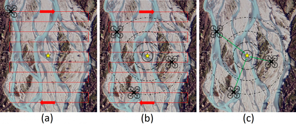
Figure 2: (a) Drone zig-zag flight path over the study site; (b) received recovery signals at multiple locations along the flight path; (c) triangulation of Kinematic Logger location based on received signal strength.
The largest of the three flood events that the NIWA team have studied using Kinematic Loggers was in the Rangitata River (Figure 3). This flood caused substantial changes to the riverbed and channels, transporting the stones up to 188.6 metres downstream. The team located and recovered the stone sensors after the flood waters had receded, and the sensors had successfully recorded stone rolling and impact accelerations.
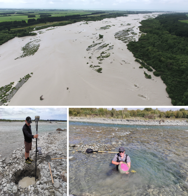
Figure 3: Rangitata River flood (top) where ‘Rolling Stones’ were successfully deployed and recovered. Project team members Julian Sykes (bottom left) and Jas Robb (bottom right) recovering ‘Rolling Stones’ that were deeply buried following the flood. Photo credit: Hamish Biggs, NIWA.
Findings from the sensor data showed that all of the stones that moved had done so by rolling in bursts, with no evidence found for gradual motion due to sliding. During their rolling, large impact accelerations led to large changes in the stones angular velocities (Figure 4). They were also observed to prefer rolling around the longest axis (a stable rotation axis). Other phases of motion were also recorded that were characterised by a lot of small impact accelerations, but without any rolling or orientation changes of the stone. These were interpreted as impacts by smaller stones from the riverbed passing around (or over) the static (and likely partially buried) sensor stones.
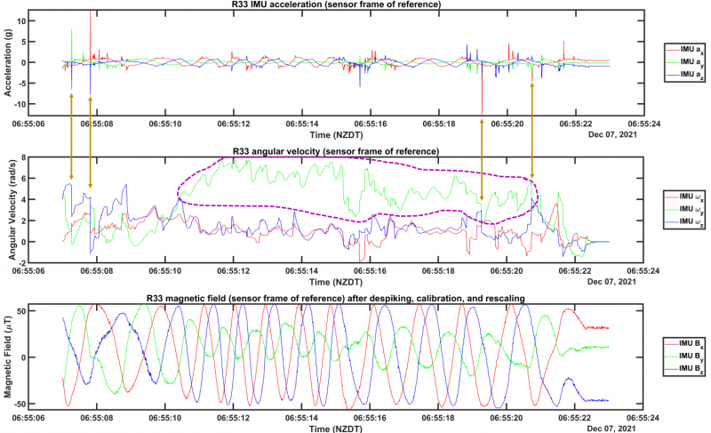
Figure 4: Inertial measurement unit (IMU) data from stone R33 during a rolling event showing acceleration (top), angular velocity (middle), and magnetic field (bottom). Motion was characterised by large impact accelerations that caused changes in angular velocities (examples shown with gold arrows). After initiation of rolling, the stone entered a stable rotation mode around the longest axis (purple dashed region) where rotations in excess of one revolution (i.e. 2π radians) per second were achieved.
Work by the team is ongoing, and using sensor fusion algorithms, the team hope to interpret absolute stone orientations in the context of channel and river flow direction to better understand stone deposition, mobilisation, and impacts. They are also investigating the data to better understand angular momentum, rotational kinetic energy, and impulses (momentum changes) during stone motion.
This research has the potential to improve how we monitor, model, and manage coarse sediment transport. The Kinematic Loggers could also be applied to studies of rockfall and landslide dynamics. Discoveries from this work could lead to important improvements in environmental monitoring in Aotearoa (and globally), increasing our understanding of how the environment is shaped.
For further information please contact the project PI: Hamish.Biggs@niwa.co.nz
Additional information: Development of the Kinematic Loggers and recovery systems
Additional information: All published research will be available here
RESEARCHER
Dr Hamish Biggs
ORGANISATION
NIWA
FUNDING SUPPORT
Marsden Fund Fast-Start
CONTRACT OR PROJECT ID
NIW1802
