Research
Published 10 November 2020The forgotten glaciers of Te Ika-a-Maui
Glaciers are iconic symbols of New Zealand’s landscape. While the glaciers of the Southern Alps are the most numerous and famous, several glaciers remain in the North Island and are no less affected by our changing climate.
A new review in the New Zealand Journal of Geology and Geophysics outlines recent advances in our understanding of past and present glacier change in Te Ika-a-Maui/North Island.
Glaciers form in areas where the winter snowpack regularly survives the summer melt season. These annual snow additions compress the underlying snowpack, squeezing out the air to form glacial ice. Air temperature is the key determinant of glacier occurrence, controlling both the amount of precipitation that falls as snow during winter, and the amount of summer melt.
Aotearoa sits approximately halfway between the equator and the pole, and our summer snowline averages about 2000 m above sea level. The summer snow line elevation varies with latitude, creeping a little lower in the far south where it is colder, and a little higher in the north. Glaciers exist where the land surface rises high enough to intercept this climatic threshold.
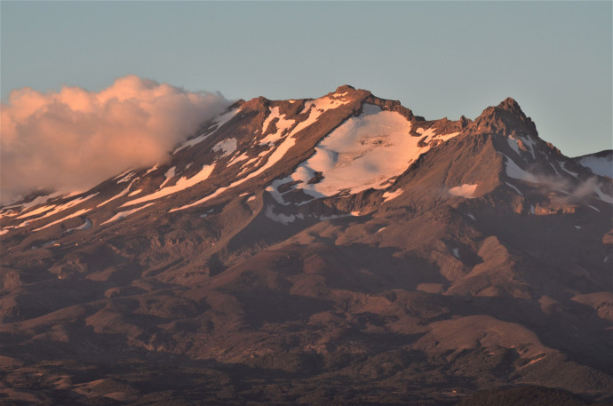
This simple interaction between topography and climate broadly explains the distribution of glacier ice we see both in New Zealand and around the world; the largest glaciers exist where the land surface projects highest above the summer snowline elevation, e.g. Aoraki/Mt Cook. In the North Island, the present-day summer snowline sits at about 2600 m, which is only intercepted by the island’s highest peak, Mt Ruapehu (2797 m). Retention of snow on the summit feeds several glaciers that cover approximately 3 km2 in area.
Climate change is causing summer snowlines to rise and glaciers to retreat all around the world. Over the last 100 years, the average air temperature in New Zealand has increased by about 1°C, which is equivalent to a 200 m rise in the summer snowline. For glaciers situated close to the topographic threshold, like those on Mt Ruapehu, these changes can be fatal to the glacier’s existence. A recent survey of all glacier ice in New Zealand found that the North Island glaciers had declined in area by 25% since 1988.
Observations of the relationship between Mt. Ruapehu’s small glaciers and local climate provides a useful analogue for other glaciers that used to exist in North Island mountains. At the peak of the last ice age, about 20,000 years ago, the summer snowline was about 1 km lower than present. At this elevation (approx. 1600 m) small glaciers, like those on Ruapehu today, formed in some lower elevation North Island mountains, such as the Tararua Ranges. At the same time, larger glaciers formed on both Mt Ruapehu and Tongariro volcanoes.
Glaciers flowing over the land surface are effective agents of landscape change. They pluck apart the underlying rock and move rocks and sediment to their margins, where the debris piles up in ridges known as moraines. These landforms can persist in the landscape for tens of millennia. Meanwhile, glaciers on active volcanoes interact with the lava during eruptions to produce unique ‘glaciovolcanic’ landforms such as columnar-jointing and unusually thick lava flows. Recent work led by GNS Science documented these landforms in a map that permits precise reconstruction of former ice geometries. Using these geological targets, numerical glacier modelling showed that New Zealand was about 6°C colder than present during the last ice age.
At the end of the last ice age, greenhouse gases and air temperatures rose, causing the summer snowline to rise and glaciers to retreat. This represents a useful natural experiment that provides insight to the currently ongoing anthropogenic climate change. Continuation of present-day temperature increases will undoubtedly lead to further reduction of the winter snowpack and glacier loss on Mt. Ruapehu.
Going forward, it would be useful to know how much and how fast North Island snow and ice will change over the coming decades. These frozen resources are central to local skiing and hydropower industries, and influence volcanic hazards, such as cone stability and volcanic mudflows (lahars).
“Glaciers and glaciation of North Island, New Zealand” is authored by Shaun Eaves (VUW) and Martin Brook (UoA) and is available in the New Zealand Journal of Geology and Geophysics.
Shaun R. Eaves & Martin S. Brook (2020) Glaciers and glaciation of North Island, New Zealand, New Zealand Journal of Geology and Geophysics, DOI: 10.1080/00288306.2020.1811354
RESEARCHER
Shaun Eaves